
Services
Complete geological support, from the feasibility stage to the filing of documents and site supervision.
Geological and geotechnical reports
The documents that accompany the structural design and the building permit, drafted in accordance with Ministerial Decree 17/01/2018 (NTC 2018) and the 2019 implementing Circular.
Geological report
Geological, geomorphological, hydrogeological and seismic framing of the site; reconstruction of the reference geological model based on the surveys; assessment of geological hazard and of the feasibility of the works.
Geotechnical report
Physical and mechanical characterisation of soils, definition of characteristic parameter values, geotechnical model and bearing capacity checks on soil and rock: ultimate limit state (ULS) and serviceability limit state (SLS), absolute and differential settlements, angular distortions.
Geological, geotechnical and geophysical model
Construction of the model of the significant volume (D.M. 17/01/18), synthesis of data from boreholes, tests and geophysics, interpretative sections and design parameters for structural calculation.
Foundations, excavations and ground improvement
Choice of foundation level and type, excavation support works, local and global slope stability checks, guidance for consolidation works and optimisation of foundation soils.
Slopes and foundation ground for reinforced-soil embankments
Geological and geotechnical characterisation of slopes and of the foundation ground for reinforced-soil embankments. Reconstruction of the stratigraphic and hydrogeological setting, interpretation of in-situ investigations and definition of the reference geotechnical parameters for global stability analyses and for the choice of the slope stabilisation or embankment construction solution.
Seismic surveys
Measurements carried out directly on site with our own seismograph, for the seismic classification of the subsoil and the dynamic characterisation of soils.
1D and 2D MASW
Multichannel analysis of surface waves (Rayleigh) from active seismics, with a 24-bit seismograph and 24 vertical 4.5 Hz geophones. It provides the shear-wave velocity profile VS, VS,eq and the subsoil category according to NTC 2018.
HVSR microtremors
Horizontal-to-vertical spectral ratio (Nakamura technique) with the SR04 Geobox three-component seismograph, to determine the fundamental resonance frequency of the site and check for possible double-resonance effects with the structure.
Seismic refraction tomography
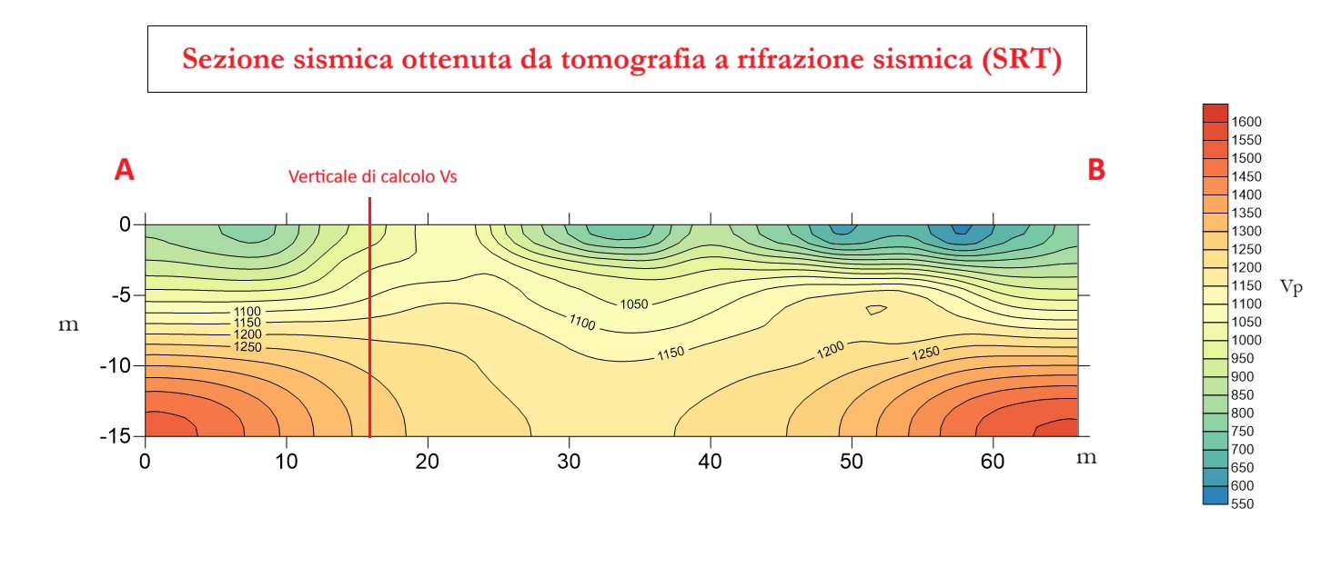
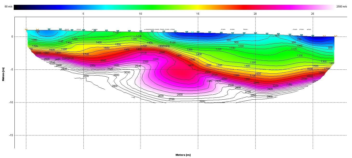
Reconstruction of the P-wave (and, where required, SH-wave) velocity section along the profile and with depth. Details below.
Integrated geophysical model
Cross-checking between the different methods (MASW, HVSR, refraction) for a coherent and verifiable subsoil model.
Geoarchaeological surveys
Geophysical and geological support for preventive archaeological investigations, reconstruction of palaeosurfaces and palaeochannels.
Seismic refraction tomography (SRT)
Seismic refraction tomography (SRT) is an investigation technique that makes it possible to reconstruct the make-up of the subsoil in a non-invasive way, turning the travel times of elastic waves into a «section» that shows how materials change with depth and along the profile.
During the test, controlled waves are generated and the signals are recorded by sensors laid on the ground; processing produces a velocity map: lower values are typical of soft, reworked or weathered soils, while higher values indicate denser and more competent layers.
This information is valuable because it makes it possible to:
- estimate the thickness of surface cover;
- identify discontinuities and weaker lenses;
- recognise the depth of the rigid layer that matters for foundations and excavations;
- support the assessment of local seismic response.
In-situ tests and surveys
Dynamic penetration tests
Estimation of soil resistance and compactness, rapid stratigraphic reconstruction and correlation with geotechnical parameters, using our own dynamic penetrometer.
Permeability and groundwater tests
Falling-head tests in boreholes or pits to estimate the permeability coefficient; detection of the presence, characteristics and level fluctuations of groundwater.
Trial pits and exploratory trenches
Inspection excavations for direct recognition of the soil succession, sampling and checking of the water-table level.
Borehole assistance
Design of the geotechnical investigation programme, supervision and assistance during drilling, core description, planning of SPT tests and sampling, installation of piezometers.
Local seismic response and liquefaction
Local seismic response (RSL)
One-dimensional analysis of seismic motion propagation, with definition of site response spectra when classification by categories is not sufficient or when a site-specific approach is more conservative.
Liquefaction assessment
Evaluation of the liquefaction potential of saturated sandy soils with methods based on in-situ tests (VS, penetration tests), calculation of the liquefaction potential index and of expected settlements (NTC 2018).
Seismic microzonation
Studies in support of planning (levels 1–3) and consistency between the project report and municipal microzonation studies.
Parameters for structural analysis
Supply of spectra, peak accelerations and soil deformability parameters for soil-structure interaction.
Hydraulics and stormwater management
Hydraulic and hydrological invariance
Calculation of flow rates, sizing of attenuation volumes and invariance devices, report and certification in accordance with the Lombardy Regional Regulation.
Hydraulic compatibility studies
Verification of the compatibility of works with the watercourse network and with flood hazard (PAI / PGRA), in support of plans and permits.
Hydrogeology
Studies of groundwater circulation, water-table depth and fluctuation, assessments for discharges and underground structures.
Sustainable drainage
Guidance on infiltration systems, permeable paving and green roofs, consistent with the real permeability of the soils.
Land planning and consulting
Geological component of urban planning instruments
Drafting and updating of the geological, hydrogeological and seismic component of municipal plans (PGT) and variants, feasibility maps.
Geological site supervision
Works-in-progress control of excavations, foundations and support structures, checking the match between forecasts and actual conditions.
Technical and legal consulting
Technical assistance in litigation (court-appointed expert / party expert, CTU / CTP) and legal consulting in geological and environmental matters: ground instability, foundations, water damage, landslides.
Geological due diligence
Assessment of the geological constraints and critical issues of an area being acquired or developed.
Land restoration and quarrying
Geological support for quarry projects and for environmental recovery and redevelopment works.
Civil, rural and industrial structures
Geological consulting for civil engineering, with particular regard to subsoil investigation and exploration for shallow and special foundations.
Not sure which surveys your project needs?
Send me a description of the project and the address: after a first review I will propose the most efficient path, with timing and costs.